Sunday, October 19, 2008

Carrots thole maduthuva jagah (Where they wash carrots) ...


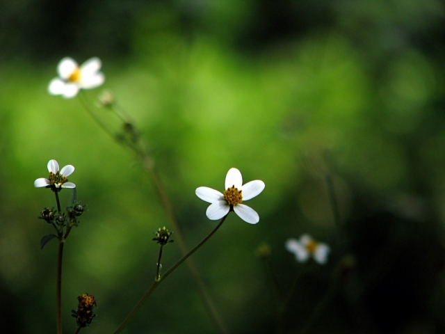
Click on the image to view the picture set ...

Yes, there is such a place! and err, no, the answer is not 'The Kitchen'. Well, there may be many such places, but one among them is a small village called 'Narsapura' on Kolar road about 60 km from Bangalore. This is a small place where there are lot of carrot fields around. After the harvest, the newly plucked carrots are very muddy. Caked with peels of mud, they have to be washed clean before shipping them to the markets; and here they do that in a big lake, lumping them together in large coracle shaped baskets made of some kind of roots, stems? and ceremoniously washing them in groups. And this is some ritual that can hold a lot to enthuse a bunch of shutterbugs. Red carrots with green leaves in brown colored coracles being washed in a coffee colored lake!

But 'Narsapura' was not anything like our destination when four of us, Me, Bejoy, Lijo and Bobbinson started from Bangalore on a Sunday morning in a no fixed plans, neither unfixed too, trip. Three of them are admittedly more 'mature'? and advanced shutterbugs than me! I like driving in the morning, getting up at 5 O'clock and driving through outer ring road. The roads dark and empty, yellow street lights blinking here and there, with the mandolin of U Srinivas on the background, it makes you feel so so refreshed.

The four of us met up at the cable stayed bridge in K R Puram. Thought we would get some nice snaps of the sunrise, but it was hopelessly cloudy and on top of it the sun made a mocking laugh at us from behind a gray veiled sky. But one let down is nothing, we decided to drive along the highway with no particular destination in mind. We stopped for tea on a roadside shop and Bob mentioned about the place where they wash carrots. Apparently some of his friends had once visited the place while they were coming back from some trip and got some nice snaps out of it. So we tentatively declared it as one destination for our trip. But he had no idea where it was or how to get there and 7.30 on a Sunday morning is not really a good time to wake a 'close' friend and ask him such questions as to where do they wash carrots on Kolar road!

So we kept on drifting through the highway.

Lake  placid ...


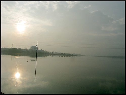
We passed this vast water body on our way, I don't quite remember the name of the lake. It may look good in photos, but the lake seemed extremely polluted :-(

Next idea came up - that we could visit vineyards near Hoskote. We stopped near a bridge where we could see something like a vineyard? The wide grass fields near the bridge were really beautiful and fresh in the dewy morning. We got down to the alleged vineyard and discovered that it is Kovakka, or tindori or gentleman's toes (as opposed to lady's fingers!) We saw lot of snails there, lots and lots of them, so much so that if you put your feet down carelessly you'll tread on one and crush it! The owner of the field, whom we met there, explained to us that there were three different species of snails found there. He knew a Kannada, at times a bit too fast and rustic for me to catch on, but communication in such circumstances is a joy! Sometimes its nice to see the curse of Babel tower backfiring on God's plans to only instill confusion among his herd ... :-D

Life gets thorny at times ...


Leaving the 'vineyard' behind we moved on. Stopped at some brick making places lined with green fields, and in fact found one or two real vineyards. But the vines were barren, there were no grapes and both of them were closed and barricaded with no one in sight so we didn't enter.

By this time it was morning enough to wake up the friend, and he told us that the place's name was Narsapura. We asked for Narsapura in the next teashop by the roadside and got directions. Its some distance before Kolar, after a petrol pump, past a Kamat Upachar you have to divert from the highway to the left and after about 2km on that road you'll hit Narsapura.

Three ballerinas ..


Then we stopped for breakfast and during that another suggestion came up. There was supposed to be a Shiva temple near Kolar with a thousand shiva lingas. But no one knew what it was called. We asked the friendly waiter at the hotel but he knew nothing of shiva lingas, not even one, leave a thousand. But he was kind hearted enough to ask someone else and came back to tell us that it is called 'Kodi Lingeshwara Temple' and is past Kolar some 17 km further. Ok, so 'Kodi Lingeshwara Temple' was fixed as the ultimate destination after visiting which we'll head back to Bangalore.

As soon as you take the left to Narsapura, the scenery changes, and you can't help feeling that you are traveling on a country side road with occasional big banyan trees along the side of the road and some plush green open land to the left and cool clear wind on your face. We hit a coffee colored lake soon, probably it was so muddy from washing of so so many carrots! :-D Couldn't find anyone washing carrots though, but we stopped by the lake bund. The place held a thriving ecosystem, and is doubtlessly dotted with some kind of powerful aphrodisiac. Every insect, or rather pairs or insects - butterflies, beetles, dragonflies - that we found there were either courting or had progressed way past that phase!

Sooo sorry to've bug'd you now ...


There was an old man, angling in a small pond there. Poor fellow, somebody had tricked him saying there were fish to be caught in that tiny pond! We asked him where they washed carrots there :-D. He gave some directions, and all the while we were running behind the courting creatures he was sitting patiently with his hook and line. He finally gave up just before we decided we got enough of the shameless foreplay and thereafter, in public display.

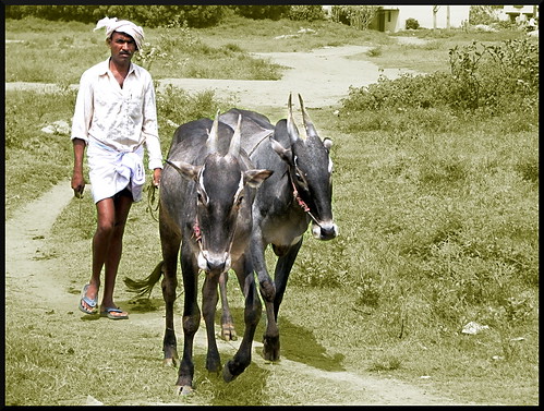
So we reached Narsapura 'town' and asked someone 'Where they washed carrots there'. He came with us and lead us to the side of the lake in one of the in-roads. We could see the huge coracle shaped baskets that they use to wash the carrots. But there was no one washing carrots right now, instead two women were washing their herd of goats in the lake! Do goats like to be washed? I'm rather inclined to say no, one of the little ones was shivering like anything after he swam back up.

Carrots didn't seem to be coming, and after waiting for sometime we decided we'd rather head for our second destination 'Kodi Lingeshwara Temple' and check on the way back for carrots being washed. On our way out, a bunch of local women led us to a small temple on the side of the lake and near the fields. They said it was 'Ohm Shakthi Matha'. Ohm shakthi matha resided inside a small pond embodied in a strange looking idol, starkly different from the rest of the temple. We got three bottle gourds as the blessings of 'Ohm Shakthi Matha' and one red rose. May shakthi matha preside over these green fields and people in unbroken piece and harmony.

Back to Malgudi ...


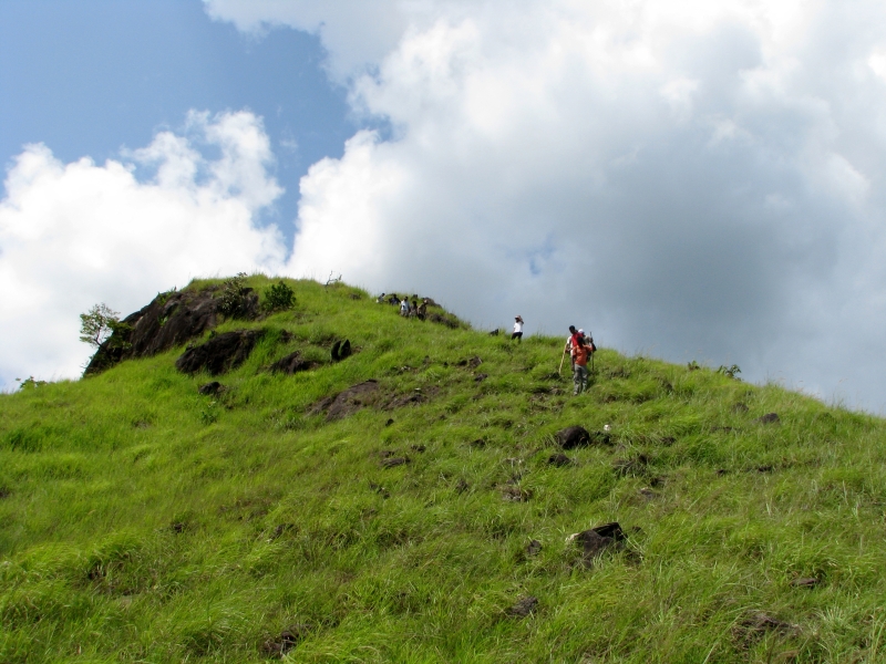
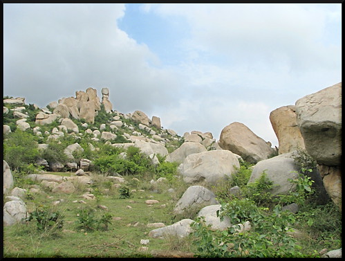
Back on the Kolar highway, Kolar was some 20-25 km further ahead. Bob and Lijo in a bike ahead of us slowed down and broke off from the road and stopped at the foot of the medium sized no man's hill by the side of the road. There was a curious shaped rock at the top of the hill, a Totem which looked like three rocks on top of each other. Me and Bejoy were initially reluctant to get down, Bob and Lijo went and called us from inside saying its an awesome place. Running the risk of them calling to trick us also into walking up and finding only some hopeless rocks, we got down and walked through the trail a bit. The place was indeed imposing, and tempting to be explored further. Especially the Totem rock, like a carrot held in front of a donkey, urging it to move ahead but always seeming distant. We had to get back to Bangalore before evening and getting to 'Kodi Lingeshwara' looked very less likely if we decided to climb this Totem rock!

Totem rock ...

Kheir,

हसीने जनम लेत हैं, की दीवानों को
तडपा सके बार बार;
पर्बतें उभर आते हैं, मुज़ाफीरोम को
फुसला सके हर ऐक बार!

So foot by foot, meter by meter, we ended up going deep and up in to the bushes that raise to the Totem rock. The way we were going up there seemed to be no trail, so we hastily and very wrongly concluded that we would be the first non-goats to summit this peak! Lijo gave up the climb after sometime, as it was getting difficult with lots of thorny bushes and the absense of anything like a trail. It was my longtime wish to climb up something like this, an unknown, unnamed, unclaimed hill, one among many that you see by the side of the road, and it felt so good!

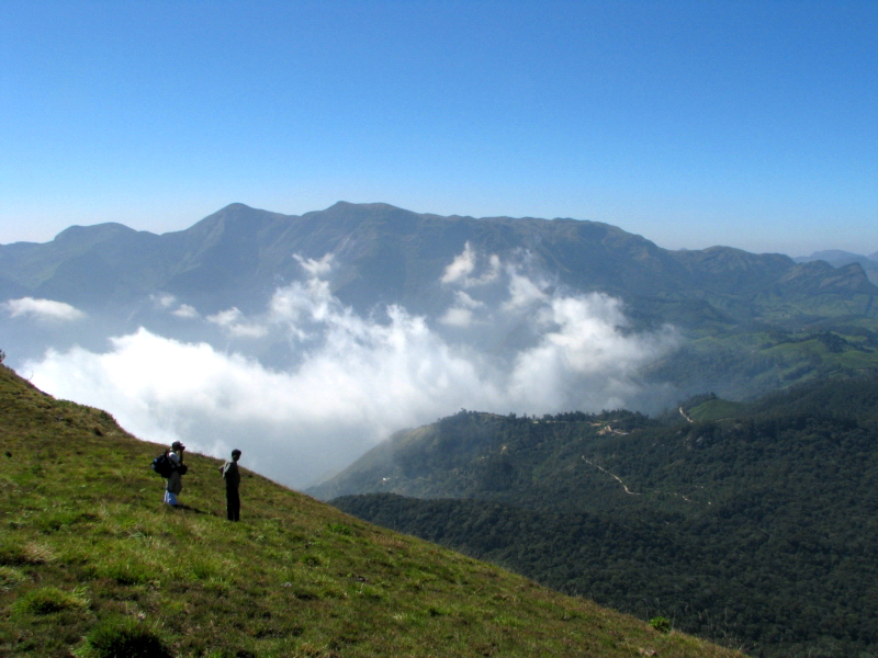
We did reach the top, a rock that we christened 'The Phantom Rock', but it was not the Totem rock. Totem rock was somewhere to the right further. Here there signs of a some one having tried to build a rocky enclosure, maybe a temple? so surely we were not the first non-goats atop these majestic rocks! We tried to reach a Totem rock, and finally managed to reach the bottom of it. It was sheer single rock about 100 ft high, the front side with two deep groves developed by erosion giving it the look of a Totem of three big rocks. The view from there was breathtaking, we could see our car and bike far below, and the road winding like a black serpent through the green lands. On the top of the hill, there is a tiny tiny water body, one with its own biodiversity. Strange little green water plants, tadpoles, water beetles? and tiny frogs - Life endures. We christened two more rocks - 'The Dog Face' and the 'Elephant's Back'. May they bear the foot prints of the great explorers till ages to come!

We spent about an hour there basking in the heights, and on the other side of the hill we met some kids and grazing goats. They were coming through a trail, which actually extended to this side and went down the hill. We descended down the trail and it was much easier than making your own road. Poor Lijo was waiting all this while down below for us to come back! We turned back towards Bangalore, had lunch at Kamat Upachar, and took a bypass in Narsapura and couldn't check for carrots being washed!

Le'me tell you that story ...


But on the way back, by the side of the highway we saw this family - a grandfather, grandmother, sons, their wives and children and a large bunch of err, not carrots, but radishes! And they were indeed washing these radishes in the near by coffee colored pond! We stopped by, bought a bunch of radishes, watched them wash radishes, took snaps, showed them the snaps to their great amusement and smiles - 'what in the world are you 'nuts' gaining by photographing radish being washed?', bid adieu and continued our journey back to Bangalore.

read more ...

Thursday, October 2, 2008

Thadiyandamol - of the mist, and sun ...


Click on the image to view the picasa web album ...

August gone, September ticking away and October tapping at the doors, monsoon's grip over southern India progressively loosens and the western ghats become far less a place that'll force you for involuntary blood donation. The leaches mostly retreated to deeper and damper parts of the forest, its the time to go trekking!

When registering for the trek to Thadiyandamol by Bangalore Mountaineering Club, I was expecting a small group like the ones I've been on with BMC. But the number of email ids in the To: list of the participants confirmation mail ran to 30-35 and I thought, mm .. lots of people, and then comes the final mail listing 47, wow! this by far is the largest group that I have trekked with!

Thadiyandamol is the highest peak in Coorg or the Madikeri district standing at 1750 Mts(5729 ft). But compared to many other peaks in the ghats its not that tall and the trek is more or less easy to only slightly moderate . No beginner should have much difficulty in summiting this one. Its about 250 Km from Bangalore, the nearest town being Virajpet on the way to Madikeri. On the base of the mountain lies the Kakkabe village which is connected to Virajpet and Madikeri.

Our group left the sleepy roads of Bangalore at about 11.30 in the night on 26th September. I was a bit tired and wanted to catch some sleep to recharge myself for the trek next day. The bus kept on tossing me at will in my seat, but owing to the great gifts of evolution through countless night-bus trips, I think I rather slept well.

Our bus pulled up at Virajpet at about 5.45 in the morning. After some futile attempts by the BMC reps Sathish, Apun and Janak to find some accommodation for the big gang, by 6.30 or so we got in to one small lodge. I think we must have taken up probably all the rooms in there! .. :-)

After freshening up a bunch of us got out and found this 'Sabarigiri' tea shop outside. Boy! do I love the taste of a 'Kerala' chaya after a long time! I might be biased, but the malayali 'adicha' chaya is the best milked tea on the planet :-) and then well, brewing tea is one of the complex processes that can send even the most modern supercomputers of 'Heart of Gold - the ship with the incredible improbability drive' to go into loops .. :-D

Breakfast of idlis done, we again boarded the bus. Sathish announced the plan - we were going to a waterfall close by first - Chelavara falls - and trek the peak in the afternoon. This is a small waterfall amidst coffee plantations some 17km from Virajpet. The weather was very bright and sunny with a cool breeze blowing. The bus wound through the laid back roads of the country side. Coorg is a nice region with lots of greenery and large coffee plantations lined with green bush hedges. After about an hour or so, our bus stopped on a village road. We were to walk some 3kms from there to reach the falls. You could also hire local jeeps from here that would take you to the falls. These areas are sparsely populated and on either side of this road you mostly find plantations.

All the coffee, cardamom and other spices and herbs growing in here give a heady scent to the cool air. You have to give it a moment or two, stop, and let the air fill you, breeze past you, and as it swirls around you slowly you can sense the exotic tingling of the aroma in the air. On the same lines, a point to ponder; You watch the scenery, listen to the voices, and ... err .. listen to the smell?? or smell the smell? na, that doesn't sound very good, take in the smell maybe .. :-) Why doesn't smell have that many words for experiencing the sensation? As it is not such a vital skill or a much developed one with human beings? :-/

Though it was said to be 3 km, the walk seemed quite a long one. We met very few people on the road and maybe a couple of jeeps coming back from the falls with tourists. The road sides were lined with loads of small flowers, wild and colorful ones; cheerful and fresh from the showers not so long ago. We passed a small school were children were singing some morning anthem and soon could glimpse the waterfall at some distance. Seems this waterfall is known as Emepaare locally, meaning something like 'the tortoise rock' in the kodava dialect. The water gushes down a large rock supposedly shaped like a tortoise. It is a small climb from the normal road, both the bottom and the tops of the waterfall are accessible by small trails.

Get down in the trail that goes to the bottom, scramble a bit at one or two narrow stretches, and as you emerge on to a rock ledge, you're suddenly treated to the sight of this delightful, miniature yet majestic looking waterfall. The rock ledge extends almost till the bottom of the falls. Though a bit slippery you can stand there and look up and see the water cascading down. For the size of her, she was generating a lot of spray, constantly clouding my specs with the mist. The water was very cool, I could extend my tongue and taste the spray, a lil salty and green. You could sit there any length of time, listening to the roar of the water around you and basking in the cool spray, till the group leader Apun announces we have a peak to scale and have to start back.

Now the sun was straight up and shining brightly and it was hot. While walking back, we began collecting plastic waste littered on the road. Even from this not so largely popular spot, we collected something like 5-6 bags of plastic waste. As 'Calvin' says, sadly our descendants have no way of refusing to inherit the earth after we make it a mess. :-(

It was about 1 O'clock in the afternoon when we reached the junction where our bus was parked and from there we proceeded to Kakkabe village at the base of Thadiyandamol. Theres an old palace here called Nalaknad palace. 'Nalku Naadu Aramane' in the local language meaning palace of four villages. This was built by the Kodagu kings as a hunting lodge which they later used as a shelter when the British army invaded Kodagu. It is now looked after by department of Archeology and is maintained quite well. We had lunch here, of heat and eat MTR curries, bread, jam, pickles and chapathis. The peak is about 8 kms of walk from here, and there is one place at about 3-3.5 kms up with a building and surroundings that you can use as a base camp. You can do a one day trek to this peak, climbing in the morning and coming back in the evening, but it also means you'll miss the two best times of the day to be at the peak, i.e when the sun sets and when it rises. Its much better to plan for an overnight stay. We were carrying tents and food for the big gang of us for the overnight camping plan. Initially the plan was to distribute the load and carry it all the way up ourselves, but luckily we could arrange a jeep to take the heavy stuff to as far as the jeep could go, which is about 4-4.5 kms up. About 5km up, at the bottom of the actual peak, there's a patch of flat land and a stream flowing. Our plan was to camp up there. So it meant we have to carry the load ourselves only for about a kilometer. We started the hike at around 3.00 O'clock in the afternoon.

The initial part is a rather steep incline through a narrow but tarred road that goes up through a plantation. This road is actually motorable. Hitting a steep incline at the very start itself works great to take your breath out! :-) The tar road ends after about 2kms and we started walking up a mud road. After some more distance one reaches a fork on the road, with a small board there indicating that we have to go left and the peak is about 4.8 kilometers from here. This point offers a good view of the sprawling valley and Coorg below. Soon we came across the base camp building, anyway we were not planning to camp there. We kept on walking an suddenly emerged on to the side of the hill. Till now we were winding up a hill which was actually hiding the real peak from our sight. I think it is not possible to see the real peak from the bottom, i.e the Nalaknad palace place. It was actually a large range of mountains that lay in front of us. There was an isolated steep peak to the right, but the highest point was further to the left on a slightly less steeper and broader peak.

We met the parked jeep and divided up the tents, sleeping bags and food stuff among us and moved forward. At around 5 in the evening we reached the camping site. The stream could be heard towards the left of the camping site and there is a big rock here from the top of which you can get a good view of the surroundings. The topmost peak is about 1-1/2 hours from here and the trail gets steeper and more difficult to maneuver. We unpacked the tents and set them up. About 20 of us set out to climb the peak before sunset, the rest stayed back at the campsite.

Initially we thought we will go to the steep single peak to the right, but soon we realized that the trail doesn't go to that one actually. In fact there's no trail to this peak, which also means not many people go here. Continuing on the trail we could see another high point to the left but that was a decoy. The trail disappeared behind that rock, emerged out and started rising again. The mountainside was laden with green, covered with lots of grass, and sprinkled with bright colored small flowers. Indeed this is a good time to trek here. After sometime the trail entered into a thick forest. The large trees and the overhanging vegetation completely cut the sun out and it was like moving through a dark cave of foliage. Emerging out of the forest after some time we could see a protruding edge up above and were happy to find the peak so within reach. But it turned out that this also was a deception when we reached there. The trail went around this edge and was rising sharply. From there it looked like it will take much more time to reach the peak. It was around 5.45 pm now and I surely wanted to reach the peak before sunset, probably to take place at 6.15 or so. But alas, my legs were not concurring! The going got very slow, and each couple of steps warranted a break. I could see our tents from here, looking like a bunch of large bright colored flowers amidst the greenery below. I could see the real peak now, up and above, and couple of us were already there. It's 10 more minutes to six now. On the principle of tangible targets I decided that I will reach the peak before six!

So I took a short breathing break, gathered all the energy and started, stopping no sooner than about fifteen steps! Four minutes were over now! and maybe about 200 meters more, did it get more steeper just now?! Strange that human emotions have no bearing on physical laws; the seconds hand of my watch adamantly kept on walking past the marks around the dial in a monotonic ritual! Step by step I covered the incline and was on a rather plane streak now till the top, 4 minutes remaining. I ran, or tottered .. :-) and reached there with about two minutes to spare, Hoorah!!

I gulped some water and stood there for couple of minutes. The sun was to the right in a big cloud of mist. I could see the valley to my left and at a great distance below the small colored dots which were our tents. Five to six of us were here at the peak and the rest of the gang were seemingly much behind. It was getting cold and the wind constantly howled in my ears. I walked down the other side of the peak a bit and sat on a rock almost on the edge of a ridge overlooking the great valley below. Chances of catching the setting sun looked less as it was already behind thick white clouds. The valley below lay calm and serene, but it was also a battleground where an intense combat was going on. The armies of white mist wanted to conquer the valley and settle there for the night, but the soldiers of the green canopy were resisting the bid with all their might. From the vast fleet of white clouds behind the mountain, many a platoon of mist dived in to the valley, fought valiantly over the green canopy before disintegrating and dissolving into thin air. And this went on, again and again, the mist could not get its hold on the valley, it seemed they were fighting a loosing battle. But soon things changed with the arrival of stronger winds to the aid of the armies of the mist. The wind lifted up mammoth arms of mist from behind the mountain and threw it in to the valley, and not just from one side, but from three sides. And slowly, very slowly the green valley disappeared and great white sheets of mist settled in the valley to spend the night.

It was getting dark now and cold, and we had to reach back to the tents. Armed with torches we started back at around 6.30. Trekking down was made slow by the lack of light and loose rocks here and there. We reached the camping site by 7.30 or so, and thanks to Apun and others who stayed back, there was already a bonfire and hot soup brewing in a cauldron.

It was clear night, not even a single cloud in the sky and it was moonless, which was almost at the end of its waning phase at this time. And when you lay on top of the huge rock the sky hung above you like a giant dark bowl. And stars, thousands and thousands and thousands of them. You could make anything you wanted from these stars, like John Nash in 'A Beautiful Mind'; An umbrella, ice-cream cone, a dolphin, crocodile, steam engine, rocket ship, and more and more. And there was the 'Akasha ganga', very clearly visible, which is the huge dense clouds of stars in the spiral arms of our very own galaxy, the milky way. It appears as a soft white milky stretch across a clear night sky like this, which I have never seen so clearly before in my life.

On the whole the gang received very few leach bites, thanks to the hot weather. But the temperature had dropped quite a bit now in the night and I was shivering. We soon had dinner and retired to our tents. Our tent was not resting on completely flat land and that made sleeping a bit difficult. Also in the sleeping bag it takes quite an effort to shift your position while sleeping! And on top of it, in the middle of the dark and cold and windy night something happened. I wanted to move my stiffened left leg a bit and while I was working it up, I heard a distinct snap. I held myself for a while and moved the leg again, and another snap; and the front side of the tent started swooping to the ground!! Me and Tarun crawled out of the tent, and to our dismay found that two of the poles in the links that ran diagonally through the tent roof were broken in the middle! There was nothing much we could do in that shivering darkness and we quietly went back inside the tent and just hoped that it doesn't collapse completely. By morning the tent was almost like a blanket on top of us, but we did weather the night!

Bunch of people who didn't come for sunset yesterday got up early and ventured to the peak to see sunrise. I decided to watch sunrise from the big rock rather than straining myself again up the peak. But from here the sunrise was hidden by the very hill that hid the peak from us when we were at the bottom, but nevertheless the crimson skies of the morning was a feast for the eyes. After the sun came up, few of us dared the elements and took bath in the stream nearby. If you withstand the stunning sting of the cold water the first time it hits you, the bath recharges you like anything. Its amazing how as the sun comes up the cold of the night gives way to searing heat.

After breakfast we began our descent, which proved to be rather easy. We hit the base in about 1-1/2 hours. We left Nalaknad by around 11 in the morning, bidding good bye to the cool coffee plantations and silver oaks. We had lunch at Madikeri and visited the Namdroling monastery, The golden temple at Kushalnagar, which is the on the way to Bangalore from Madikeri.

It was my third or fourth visit to the temple. But this time around, prayers were going on in the temple hall. The prayers of Tibetan budhist monks is a very enchanting experience, with lots of exotic musical instruments, drums and trumpets and mystic chants. Its bad that people only want to take snaps on their mobile phones posing in front of the Buddha when the prayer is going on than listening to it and maybe trying to feel the presence of 'Buddha'. And maybe for this, I felt less moved here than my experiences in some of the monasteries in the Himalayas.

We left there at about 5.00 in the evening. The bus headed to Bangalore and I tried to catch up on some badly needed sleep. After dark, the bus soon turned into a throbbing 'mehfil' with quite a gang forming in the rear contributing to the cacophonix, which included me and which drained half of my voice by the time we reached back in Bangalore close to 10 O'clock in the night.

And thanks to Prakruthi, for the delightful surprise of a home cooked dinner at the end of a tiring day.

The woods were lovely, dark and deep; I went miles through them and now should sleep.

:-)

read more ...

Sunday, May 25, 2008

Shingani - A lil surprise, or two ...


Click on the image to view the picasa web album ...

Shingani Gudda is one of the major peaks in Charmadi range in western Karnataka. Close by are other well known peaks like Amedikkalu and Sibile Gudda. At the base of the peak lies the small village of Arasinamakki. Arasinamakki is about 20 kms off from Shiradi on the National Highway 48 that goes through Hassan to Mangalore.

It was sometime since I felt the breeze at the top of a mountain! And Bangalore Mountaineering Club announced this weekend trek to Arasinamakki and Shingani Gudda. I did register for the trek early enough, though as the day neared there were quite a bunch of things cropping up tending to push me off the plan. But the pre-paid non-refundable fees for the trek was one strong point in the favor of the trek! So there I was starting on this trek from Bangalore on one of its traffic jammed Friday nights on 17th May 2008.

One has to go from Bangalore to Hassan, then to Sakhleshpur, and keep proceeding on NH48 to Mangalore and get off the highway somewhere near Shiradi to go to Arasinamakki. We were a gang of 15, bunch of them first time trekkers and some with quite a lot of trekking experience. I think this was a new trek for even the BMC organizers and they had categorized this as an easy to moderate trek ideal for beginners. We had a round of introductions and and as the bus plunged into the night trip I think everybody fell asleep. At least I did! I was very tired from a hard long week.

I slept pretty good, irrespective of some really bad roads after Hassan. As I opened my eyes, our bus has stopped at a small village road. All of us got down. We were at Arasinamakki, a rustic and laid back village. A small river named Kapila passes through the village. On the banks of Kapila there was this small home stay place which was going to be our base camp. The owner of the place was standing nearby and guiding us. (I forget his name, bad .. lets call him Athreya :-)

This place is basically a beetle nut plantation and quite a big one at that. Athreya has his ancestral house here, which is a two story building in traditional style. It has a big courtyard and a small dog 'Pinky' tied to one of its pillars on the veranda. This little dog got so excited seeing all these people, she was jumping around so much as if not knowing what to do next! She wants to lick you, swirl around your legs and climb on you and if you unlock her she drags you all around the courtyard round and round and round!

We left the house and went down to he beetle plantation where a bunch of huts and a small house was set up as the boarding place. Set amidst the tall beetle trees, it looked like an excellent place to relax and let go. There were couple of swings and hammocks here and there, very inviting! We put down our backpacks and started going through the morning routines. I ventured out to explore the surroundings. The river Kapila flows in front of the small house, a little below. There were a couple of bamboo rafts tied to the bank and a small tree bridge to cross the river. I crossed the river and got down into it on the other side.

In between glistening rocks and sand there were schools of tiny fish moving lazily in the slow moving stream.

Malayalam writer O.V. Vijayan in his novel 'Gurusagaram' talks about his village in the northern part of Kerala, and about the river 'Thootha' flowing through it. In the crystal clear waters of 'Thootha', above the white sands at the bottom, tiny fishes with long noses swim lazily basking in the mild sun shining above. They are our ancestors, reborn as tiny fish in 'Thootha' after they passed away from their human form. When they surface for a breath of air above the river waters they look for you, their grand children, in the light and shadows that play on the river banks.

I knelt down on the river and put my hand into it and held it still for a long time. Slowly the tiny fishes surrounded my palm and started biting me with their small teeth. Those tiny pin pricks were a queer and wonderful sensation. My hand was being caressed by the hundreds of ancestors of Arasinamakki who have died and reborn as tiny fish in Kapila. Could they know that I'm not one of their grandchildren? :-)

I went back to the hut and we had breakfast. Athreya had prepared a kind of sweet made out jack fruit. I was all the while under the impression that it was made only in Kerala. That was a nice surprise.

We started the 'easy to moderate trek, ideal for beginners' at around 9.30 a.m. A Bunch of guys arranged by Athreya were our guides. Athreya's son, a school going kid and couple of his friends also joined us in the trek. We were supposed to reach the peak and come back down at around 2.00 pm and then have lunch. we walked through the village roads of Arasinamakki - a temple, a school and a small playground, crossed the river Kapila through a rocky patch and got into the forest path. It was very humid and hence you felt really hot. I'm not sure how much the temperature was. We reached a clearing and could have a first glimpse of Shingani Gudda.

It was kind of a two step mountain. The first peak was totally covered with trees slowly rising to the second peak. The second peak had a three step culmination covered with green grasslands devoid of any trees and had a steep looking summit. Standing there and looking up at the magnificent mountain, I had the strange feeling that this was not going to be the 'easy to moderate trek, ideal for beginners' as promised. Steep peaks covered with grass and rock at the summit usually have a sting in their tail when you try to mount them. Up there, there won't be any shade and usually you will have very steep edges that need to be scrambled through.

Rising and standing tall above in front of you, the mountain is a seductress though. Most of them are. Basking in lush greens and tilting her face down to see you looking up at her, she teases you to come up to her face. Standing there, I always think how it would feel to be looking down from the top of that mountain, and always reflect upon this thought when I actually reach the top. :-)

But now we were under the shade of the forest and the terrain was not very steep. We were making good progress till the track started rising steeply. The humidity and the high temperature combined was making the climb very difficult. We had to conserve water also as the two liter bottles we were carrying looked like not quite enough for the complete trek. We often took short breaks allowing for people to catch up. One good thing was we were still climbing under shade. But that soon ended as we emerged into a clearing which was a rather steep rock face covered with grass. The grass was still lush green though it was mid summer, probably thanks to pre monsoon showers. But the sun above was boiling. The best thing to do was to scramble up this patch as fast as possible and crash in the shade at the other side and rest. But quite an effort was needed to cross that. I think beginners had a real tough time :-)

We rested for sometime after that and started climbing again. Now we were moving through dense forest and there was a
thick bed of dead leaves on the track. This probably is a haven for leeches, though at the peak of summer most of them would have died away. I soon spotted one standing up on a dead leaf on the path itching to jump on to any unsuspecting passer-by. Through leech territory, you should move as fast as possible while constantly checking your legs to spot any that has caught on to you. They can even crawl under your socks and shoes and it would be too late by the time you spot them. Once the leech has properly bitten you, the blood flow will take a long long time to stop. Couple of us had two three leeches catching onto their legs, but we quickly disposed them using Iodex sprays.

After some more time through the dense trees, we reached a rocky ledge. We were at the first peak of this two staged mountain. From here you can't see the larger peak and it almost feels like you have reached the very top! Bad thing was there was no trace of any wind! But the view from the ledge was really nice as we were above the many other small hills of this hillock range. All those energy foods people carried were out and we rested there munching on them. It was already 1.00 pm. As per schedule we should have reached the peak and started descend!

The guide said its about 30 minutes of walk from here. I thought of the view of the steep peak covered in grass from the bottom and in my mind quietly discarded what he said. We started walking again. In between, the guides took a detour down to a stream to collect water. There was no stream, it had died in the summer. But there were small pits of water from which they filled their bottles. The water looked stale but people said it indeed is flowing very slowly through rocks and craks. Though I was skeptic about drinking it, it felt really nice and cold to splash on your face and had a mineral taste. After 30 minutes we reached the beginning of the grassy patch that goes to the peak of the mountain. Two up and down steps of small hills and the final rising to the summit could be clearly seen from here. It was a wonderful sight. Generally once you can see your target, it infuses fresh energy into your legs. But while inside the forest you are blindly following the guide without really knowing where you are going and how long it will take.

I started walking right behind the guide in an attempt to be the first one to reach the summit. But beating the guide at his own turf is tough. Though the green grasslands look fabulous from the bottom, they are a burning oven. The tall grass increases humidity and temperature level, and without any shade to cover you, you are literally baking. Thankfully at this level, as it was very open, there were strong winds blowing that cooled your bodies down. It was surprising how the peak seemed so very near but so far away! I tried to cut a sideways track through the first two ups and downs to avoid climbing them fully. The guide was climbing up and down them. But I had to abort and trek back to the top of second hill as there was no clear sideways path to get to the summit hill. The last stretch to the summit was a killer again, with steep rocks and only grass blades to hold on to which were often sharp. You crawl on to a rock face thinking you have made it, and you see up there, there is one more big rock pile above you and on top of which there is this flag, a makeshift one with with a red cloth, installed by previous climbers. So you are not at the top! Regain your breath and inch forward again!!! Step by step by step we moved on. Me and the elder guide reached the top together though one of the kids actually beat us!! :-). It was 2 O'clock now.

I crashed there for a bit and then went and stood on a ledge from where I could see the clearing down below from which we watched the mountain. There was a nice and strong wind blowing across me. I stretched my hands out and let the wind push me. It's almost like I'm flying looking down in to the green valley below me. This is one thing I most like doing when I reach atop any mountain and a windy one especially .. :-)

There was no shade at the top and the sun was unforgiving. But there were huge clouds floating across the valley casting cool shades under them. The clouds move in the wind and you can see the fuzzy shaped shadow sweeping across the forest. I sat down on the ledge, egging the herd of clouds to pass over the peak and over me. It was like a game between the clouds and the wind. As soon as one huge cloud is about to caress the peak with its cool shade, the wind will break it up into small pieces and it will wither away. I'll have to scold off the wind and try to attract the next one in line and it goes on. Some of them did manage to defy the wind and bless me with their coolness, and wasn't I thankful!

From here you can see the 'Amedikkallu' peak which looks like is higher than Shingani. On top of that peak you see three huge rocks arranged in the shape of a stove and it seems there is a huge monolith that looks like a tortoise. 'Ame' is tortoise in Kannada and 'Dikkallu' is a cook stove. It is supposed to be a very tough trek apparently! Slowly people started arriving and by 2.30 or so most of us made it to the top. Some of them aborted the climb at the second up hill and were resting there. We had a round of snacks and we were all out of water. The guides said we will go down by a different path where there is a flowing stream to collect water.

We started the descent at around 3 O'clock. We trekked down the same path we came through some distance and then our guide took a detour to reach the promised stream. Four of us including me were ahead with one guide with us. The rest of the gang was a little behind. Our guide was in a hurry to reach the bottom as soon as possible and took a drastic short cut through the woods. There was almost no path at all and we were making our own road! The rest of the gang fell far behind. Somehow we reached the stream. Now this was a flowing one indeed and the water felt really cool and refreshing. We filled up and started to walk down again. We went down the stream for a short distance. It was slippery at places and couple of time I lost my footing but nothing bad happened. Our guide soon again took another detour away from the stream and into the forest which was supposed to lead us down quickly. This again was no track at all. Thing is the moment you get onto some route like that there is more than a pretty good chance that you would get lost. Though the guide may know the route, the growing vegetation will soon change the way it looks unless there is some kind of trail. And after some time we got lost as expected! I was thinking my treks were getting jinxed of getting lost of late!! But the guide did eventually find the way back and we emerged in to rocky slope which would have been a waterfall in rainy season. But now it was dry and we were supposed to get down through it and take a path that began and the bottom of the slope to go back to the village. It was about 4 O'clock now. We rested there waiting for the rest of the gang. It turned out that we were about 40 minutes ahead of them!!

At 4.30 pm we started from there through the path at the bottom of the falls. I was thinking we would reach back by 6 O'clock or so and was planning on taking a dip in the river. But the patch seemed never ending, winding on and on. I remember someone telling me that if towards the end of any trek you don't have the feeling of 'Oh my God, when is this gonna end!', then it was not really a trek! By that means, sure this was really one! And to our surprise Athreya met us on the way with chapathi's and 'sagu' which was our missed lunch! By 6.30 pm we reached the village junction and playground. Our bus came there and hauled all of us back to the home stay. It was 7 pm and any dreams of a dip in the river was completely out!

Pinky was very delighted to see us back and jumped all around. Athreya treated us with Kokkam water, it is a sweet syrup made out a spice, and potato and onion bajjis. All were heavenly to our dried tongues and stomachs! As per schedule we had plans of a night walk after the trek, which was generally abandoned now. We had trekked for about nine hours which by no means is moderate! We all got fresh and rested. For dinner Athreya had some fabulous vegetable pulav and rice and rasam. The food on all occasions was indeed very tasty and had the traditional local flavour.

By 10.30 pm we all had our sleeping bags and stuff. It was still very hot and humid and sleeping inside the hut or the house seemed to be a bad idea. Me and a few other guys decided to sleep in the open courtyard. We lay there on our sleeping bags looking up at the night sky. The moon was out and there were puffy white streaks of clouds all over the sky. It was really serene and peaceful, only marred by the constant howls and cries of Pinky who was shifted from her normal place to a corner pillar to let us sleep in the courtyard. She seemed to be very uncomfortable there and never let off the howls. So I finally got up and brought her back to her place. She was thankful and peacefully went to sleep. Slowly we were also lulled to sleep by the calm and moonlight all around.

Come morning, I was determined to take a dip in the river. But as the river was very slow moving, the rocks were rather slimy and it didn't feel good. I went further down the stream and found that there is small check dam which was making the river very slow this side. I crossed the check dam and had a dip on the other side where the stream was in full flow. No one else ventured for a dip after my feedback! Once back, I tried to experiment my skills on one of the bamboo rafts. To my surprise I could steer that thing pretty well and could get it to go where I wanted it to! I went some distance through the river and saw a bunch of cormorant like birds engaged in morning fishing. We had a heavy breakfast of queer shaped idlis and some sweet made out of dried coconut. After that Athreya turned on something like an artificial waterfall! Water was being pumped up into a tree house built over the river and let down from there! All of us got down in the river on the bamboo rafts and had a real blast in the waterfall for a long time. It felt really nice to let the water belt your back after yesterdays long trek! Our feet and hands dangling into water from all sides of the raft made a feast to the schools of fish swimming around.

Our plan was to start back to Bangalore by 1.00 pm or so. Before that we decided to visit Shishila, which is a place nearby. There is an old temple of Shishileswara which is famous for sacred fishes who are treated as healers of skin diseases. Shishila was supposed to be our destination of a river walk that was scheduled for today which was also generally abandoned! Shishila temple is like Shringeri were you can see really large fish thriving in the small river close to the temple. Fishing is prohibited. There was a cable stayed bridge across the river and we created some kind of a relay of this large school of sacred fish by feeding them alternately from both ends of the bridge. You drop something on the other side, and all of them wallowing here now will swim there in a nice and beautiful pattern, something like what the metallic spores made when as a child you had collected them with a paper and a magnet on top, rubbing it through sand.

Some of us had lunch from the temple as part of the afternoon ceremonies, while others waited to eat on the way back. We got to Hassan by 5.30 pm or so and had a stop over at one of the road side Dhabas. Huge rain clouds could be seen on the horizon and it rained a bit. We had a nice round of hogging in the Dhaba and left around 6 O'clock. Our expedition reached back in Bangalore by midnight.

Back to regularly scheduled programming till the next urge to feel the winds ... :-)

read more ...

Monday, January 7, 2008

Kodai to Munnar - The Art of Getting Lost ...


Click on the photo to view the picasa web album ...

A trip of blind uncertainties, and one in which to almost perfect the art of getting lost; this is what the Kodai to Munnar trek turned out to be.

To start with, nobody was sure if the trip was gonna happen or not, confusion about who will be joining and who is dropping out, no tickets in any of the herd of buses plying to Kodai, or to any place within a hundred kilometers of that even! But finally, the gang of seven - me, jomy, shanti, roop, abhi, shail and murali happened to be hiring a qualis and setting off to Kodai on the Friday night - 28/12/2007.

We were very late to start from Bangalore, at about 11.00 p.m. The planned route was to go to Salem, then Udumalpett, Palani and reach Kodai. While the rest of us were sleeping, or rather - being tossed here and there in the swaying van - the driver and the navigator - that's abhi - managed to get lost somewhere on the highways, didn't go through udumalpett, but somehow reached Palani and at last hit Kodai by about 11.30 a.m on Saturday morning.

Features of the night trip include stopping at roadside dhaba huts at odd hours of the night, sitting on the rustic braided coir cots and gazing up the midnight skies while the sleepy dhabawaalah lit up the samovar and made tea. Somehow the braided coir cots make you feel miserably comfortable at such hours!

In Kodai, the first mission was to obtain permission for trekking from the DFO. Our plan was to trek from Berijam lake in Kodai to TopStation in Munnar. There was a tarred road along this route that the Britishers had built. The road was closed in 1975 and after that it became a jeep track. The jeeps also stopped after sometime and then this became a forest trail. It was sparingly used by trekkers. We had read about a group trekking through this path sometime in 2006 and were planning our trip based on that. What we did not know at this point was that by the end of our journey we are gonna find the route almost completely non existent now, that the forest has grown back with a vengeance into the trail and that almost nobody has gone through the route for at least the last couple of years!

The trail goes through Kodai forest range and at the end through Munnar range in Kerala through the Pambadum Shola national park. A permission is needed from the forest department to trek in here as these are reserved forest areas. But getting permission from the District Forest Officer turned out to be tiresome ordeal. First the bunch of middlemen in the forest office would not let us meet the DFO, and when after three four times of going and coming back to the office we finally got to see the DFO, he is adamant that he can't give permission for a thousand reasons. After half an hour of pestering, he finally gave us permission to stay at the forest guest house in Berijam and walk around a few kilometers there and that was it! But somebody at the forest office tipped us off about Velayudham, someone who works in the forest department, who also functions as a guide and who by the way can get permission for anything if approached in the right manner! We called up Velayudham, and to start off he said he charged 300 Rs/- per head per day of trekking! But by now we somehow wanted to trek whatever it takes and agreed to his demands. It was almost evening time now. Velayudham redirected us to another person named Manikandan, or KodaiMani, who was to be our guide.

The moment after we met Mani confusions and uncertainties started to begin. Mani said the route we are thinking of is not at all interesting as its a plain jeep track with forest on either sides. He proposed to take us through some other routes around Berijam lake, through some resortish accommodation stuff and back to Berijam. We were kind of keen on a wild trek rather than a resort bound walk, but somehow Mani sounded convincing. Then we called up Velyaudham again and he says the Mani route is just so-so and the original route is the one to go if you want any thrills or fun. After a lot of debate, permutations, combinations and finally a vote we decided to stick to the original plan! By now it was night. We did not want to spend the night at Kodai but wanted to go to Berijam lake. Mani said the Pambadum Shola path is so full of leeches that at least fifty of them will catch on to your feet for every step! He said we will need something, some anti leech footware to avoid that. The tailor will take at least half a day to make those and so we can start our trek only at mid-day next day! But we were adamant that we go to Beijam lake for the night, so we decided we will send Mani and the driver back to Kodai in the morning to fetch The Anti Leech Software - err, footware - and start the trek from Berijam lake when they are back. We shopped for stuff in Kodai, fruits, kerosene, salt and neem oil for leeches etc. Mani tried his very best to avoid going to Berijam at night, but our stubbornness finally won over him and there we were setting off to Berijam from Kodai at 11.30 in the night.

Berijam is a fresh water lake in the controlled forest area. Usually people are not allowed there in the night though day trips are permitted. But not many people go there. It is about 25 km from Kodai, and you need to pass through three forest check posts to reach it. The saying is, in the Britishers' time they used to make jam from berries out here and that's why this places was called Berijam! Theres a forest guest house here and couple of huts and quarters for forest department employees who stay here.

After about fifteen minutes of drive we reached the first check post which is about 8km from Kodai, the guard who was a friend of Mani opened the gate and we were through. After some more time we entered the forest - the night was pitch black. On both sides of the road I could see large shadowy trees. They looked like hooded giants standing guard as the bright headlights' beam pierced the darkness. About five minutes later, we were coming around a bend, the turning light beam fell on something huge and black standing in the middle of the road. A full grown bison! looking immensely powerful, its crimson eyes were shining in the blinding light. But he turned out to be a peace loving animal and courteously moved to the side of the road. We returned the favour and moved on without bothering him much.

Sometime later we reached the second check post in the middle of the forest which was unmanned at this hours with good reason. Mani got down and took out the keys from somewhere around the check post hut - a little secret kept by a few good men. He needed help to untie the ropes and I decided to get down. I stepped out and looked up at the sky and was treated to an awesome view. The sky was full of thousands and thousands of stars! everywhere I looked - right, left, above and even the tiny patches of sky visible under tree tops were sprinkled with stars!

I had to stand like that for a couple of minutes. Others also got down and we untied the check-post, moved past it, locked it again and kept the secret back in its place. At bout 12.30 p.m we reached the final check post near the forest guest house. Mani woke up the guard who was sleeping inside the building nearby and he escorted us to the guest house. We gout our backpack down from the van. There was no electricity, and we had the dinner that we were carrying under some kind candle lights. The rooms had nice carpets and soon we were fast asleep inside our sleeping bags.

I slept peacefully. So did everyone else I hope.

In the morning we went to the lake, and 'went around' the forest. The lake was peaceful and serene with a large herd of blossomed water lilies on one side. Mani had mentioned there would be an old boat tied somewhere and that we can try it but to be very careful. Nothing on the lakeshore looked like a boat landing. We walked along the shore a bit. Only me, roop, jomy and shanti were there when we found the boat. It looked pretty shaken down, with no oars visible anywhere! But we figured the couple of wooden planks lying inside the boat were supposed to be serving the purpose. I don't think any of us were on anything like this on our own and we were skeptical about whether we should try it or not. We were no rowing experts! But there we were eventually, untying the boat, stepping in hesitantly and pushing ourselves off the shore! roop and jomy were the rowers or oarers, I was the control and shanti was the observer - she was to keep observing if the water level inside the boat was rising enough to cause alarm!

We did not move a lot from the shore initially. The art of rowing - rather getting the boat to go were we wanted it - was something to get used to. It kept on turning around and drifting, we bumped into water lilies and shanti kept on saying we should go back this moment. But with some struggle, the rowers got used to their task, and we were able to control the boat rather well. There was a strong wind blowing across the lake and it was pushing our boat into the lily herds. The lake is some sort of T shaped and approximately 3 kms in length. We rowed and rowed against the wind to reach the middle part of the lake away from the lilies. The oarers quit by now, submitting ourselves completely to the mercy of the wind. Floating thus in the middle of nowhere, in complete silence except the tiny ripples kissing the boat, a glistening expanse of water on all sides, bright sun and thick forests encircling, we were blissfully lost.

We spent much more time than we intended in that world.

Getting the boat back to the landing and parking it at the right spot turned out to be another skilled job. We did manage to accomplish it somehow. By now it was almost noon. Mani and the driver had gone to Kodai and came back with 'The Anti Leech Software' and packed lunch. Today we were supposed to trek from Berijam to a place called Nattampetti and spend the night in the forest quarters there. The next day we were supposed to trek from there and reach a wireless station in Pambadum Shola national park. On Tuesday - 1/1/2008 - by noon we were supposed to reach Top Station in Munnar from there. We sent the van and the driver off with instructions to go from Kodai to Munnar by road. He was to wait for us at Top Station on Tuesday. We started on our trek from Berijam with the packed lunch at bout 1.00 p.m.

We were walking through the broken tarred road - the jeep track. This road is called 'The Escape Route', not clear why, though some said its because the Britishers escaped through this route! After 30-40 minutes of walking through that we cut into a side trail going through a pine forest. In fact the pine trees were planted by Britishers though now it resembled a forest. After the rains the pine trees had grown fresh leaves, or rather the strands that looked refreshingly green. Warm sun rays were seeping in through the pine foliage. There were small pine trees where I could run my fingers through their fresh green strands. I queerly felt like running my fingers through a pretty girl's long and soft hair strands ... :-)

After another hour of walking through the pretty girls, some of them albeit with dyed hair, we reached another splendid lake. This was the Kaunji lake.

This lake was probably smaller than the Berijam lake but looked more beautiful. We opened our packed lunches there and relaxed for some time. We made sure we collected all the garbage in a bag to be disposed off later when we reach the village.

At 3.30 pm we started again. Mani delved into a seemingly thick pine foliage and landed us on another trail practically hidden by the bushes. This trail was smaller, and there was considerable undergrowth among the pine trees here, but these were still old planted trees. We crossed over a small stream and were soon on a wider trail that led to the Kaunji village. We rested at some place where we could see most of the valley beneath, comprising of a couple of villages. This was not really a tiring day's trek.

We had to walk half an hour more to reach the road that passed through the Kaunji village. From a road side chai shop, we had some tea. It felt surprisingly rich. From here we had to go to Nattampetti, another village some kilometers away, and we hoped to catch a bus or a van. But then, what came along chugging down the mountain road was a lorry instead! So we all climbed up onto the back of this lorry with all the luggage and settled amidst a few villagers who were traveling in that. The lorry started through the winding downhill road. It was swaying violently and tossing us all around, so we stood up holding on tightly to the railing. This was indeed an enjoyable ride passing through the farming villages with the sun setting in the background. The cold of the night was setting in and there was a pinching chill in the air. When it started to get almost dark, our lorry stopped at Nattampetti village and we all scrambled down shivering. This is really just a settlement than a village.

Mani and one of his aides there led us to the forest quarters. It was a small recently finished building - again no electricity. Mani's aide brought a pot full of water from somewhere. Couple of us worked on setting up a campfire while the rest started to prepare dinner. We were carrying a small gas stove, rice to cook, heat and eat packages, and soups, a special for a new years eve next day when we would be camping at the wireless station!

But when we were having the cooked stuff by the warm fire that we set up, Mani made a fateful proposal. Seldom did we know that it would go on to topple all our plans. He said the next day we would be walking entirely through a plain boring jeep track, and said he knows another route through the forest, but added that he doesn't know it well, that we would have to find our way through it actually, and that it would be thrilling! Since there was not really a weakling among us to pull us back, all of us ended up agreeing to this. By the end of our trek we were to learn the hard way that the jeep track itself, or rather the non existence of it, is the most difficult and/or thrilling part of the trek!

Next day we started our trek at 9.30 am. We filled water from a stream and started to climb uphill through the jeep track. We were walking along the side of the stream that formed small rapids and waterfalls occasionally. The sun was not kind and it was pretty hot. After an hour of walking we reached a larger waterfall called Vellayanthol falls. The water was extremely cold. We rested there for sometime in the ambient noise of the falling water. The sound of a falling stream is said to be one of the most calming sounds, and I can vouch that its very true.

After walking a few hundred meters from the falls, we embarked on our fateful diversion from the jeep track. It started as a tree cutters' trail into the forest. Mani was making marks on the trees that we were passing with the large machete knife he was carrying. He said hes just marking the way in case we get lost. We walked almost half an hour on that trail. It became narrower and narrower. We passed through bare rock faces, thick bushes and foliage. Mani expected to find a small broken wood bridge across a stream nearby. He said the bridge would lead us to a track which would in turn take us to the jeep track at the end.

Couple of places he went down from the track and inspected but could not spot the bridge. After some more walking through thicker bushes we reached a small clearing and a swamp. There appeared to be a small trail to the left, but Mani did not seem to like it. One of the BSNL mobiles had network connectivity and he even tried calling up somebody to ask for the route. But it did not help much. We eventually decided to go to the right. This was a very wrong decision which in fact took us far away from the jeep track.

There was a wide grassland to the right, we started crossing it. Lots of elephant dung was scattered around there. It did not look fresh, and hence was not an indication of present danger. There was no clear trail, and whatever looked like a trail ended in some thick thorny bushes. We made our way through the bushes by cutting them down with the machete, and in the process I received lot of thorn scratches on my hands. After scrambling for some distance through the bushes we emerged on a bare rock face and a clearing. I hoped Mani could spot some landmark, but he was completely without a clue. But he said we should be targeting the mountain that was to our left.

After resting there for a few minutes, we picked ourselves up again and started to seek a trail to the left. Something that barely resembled a trail was chosen and we started on it. It also was full of thorn bushes and the machete came in handy. The trail or whatever it was, rather resembled a path used by animals, and not humans. We could see lot of animal droppings, and the trail was full of hooves marks, probably bisons', goats' or something else's. Sometimes I had to wonder how can even animals tread through such a difficult trail. This path led us to small stream flowing through a rock face. This was a little tricky to cross as most of the rock face was slippery. After figuring out a couple of safe foot holds, we crossed it one by one. The other side was an even smaller animal trail. After a few hundred meters of going through thorny bushes, we emerged on a slightly wider trail that appeared to be used by humans. To the left the trail was going down and to the right it was going up. We decided to go to the right. It led us to a small clearing on the side of the hill. It was 2 O'clock in the afternoon and by now we were all tired. We decided to have lunch and gorged on the bread and jam we were carrying. The bread was all crumbled, but it sure helped the hunger.

After lunch Mani and Murali were sent on a reconnaissance mission to ascertain where we were and to find a way back to the jeep track if possible. They were gone for about 15-20 minutes, and came back with the bad news that we are probably on the wrong mountain! They found the dilapidated remains of an illegal eucalyptus oil brewing place which was raided and destroyed by forest guards. That probably explained the existence of this trail. Going back on the track we came through was kind of out of question. So we decided we will go forward and try to climb down the hill and reach a probable track that might be passing through the valley. But the forward path ended shortly on a steep cliff landing into thick forest. Mani suggested we go back on the brewing place trail and see if it leads out of the forest. We started walking back. After a few meters we had another idea - In the valley below we could see a pine plantation, like the ones which we passed on first day. This meant the other side of it would probably be a track. There was a place were the rock cliff was not that steep and we could walk down through it in to the pine forest. The rock cliff was easy but when we actually entered the pine forest, we found that it had very thick undergrowth. We were trapped amidst waist hight thorny bushes. Not much light was entering the forest floor through the foliage. It looked like we were terribly lost. For some relief, there were large fallen pine trees that made a maze through the bushes. We balanced ourselves on the fallen trunks and started walking slowly. The whole ordeal looked like an adventure from the Tomb Raider movies! Once or twice people lost balance and landed on the bushes. Struggling thus we crossed the pine forest and emerged on another large swampy grassland. There was a stream running through it, but not a sign of the promised track!

To the right was thick forest and to the left was the grassland and this time we took the left path. There were lots of bison foot prints and elephant dung on the grass. Walking further we could see something that looked like a trail at some height on the mountain in front. After a few hundred meters we spotted the broken wood bridge that we were looking for in the morning! We had taken the wrong route to the right at the first swamp and made a very big and difficult circle through the forest and came back to the correct path!!! The track from the wooden bridge went up the mountain and was the one we spotted at some height earlier.

This adventure had cost us a lot of time, it was about 3.30 pm by now, and from Mani's memory it would take about 4 hours to reach wireless station from here. We felt a bit of night trekking was okay as we all had torches. All of us started walking on the track with refreshed energy, having no hint of the tougher ordeals that were in store ahead!

The track had occasional trees fallen across it and we had go around the tree to get back on to the track. But the terrain was not difficult and we were walking fast, we did not want to spend too much time in the forest after it gets dark. A few hundred meters into the track Mani suggested we take a short cut climb instead of going through this track which was gonna take at least two hours. The short cut climb should save us an hour he said. We were very skeptic about this after the previous adventures and asked him again and again if he knew that track for certain. He sounded sure. We had to save time and we agreed to take the short cut climb. The climb was not any harder than the trails we came through except that it was climbing up. We made good time and emerged in to a wider looking track at around 5.00 pm.

This was 'The Jeep Track'! It looked anything but a plain boring jeep track, looking completely abandoned and forest grown into the track from both sides. Mani said he had trekked through this two years back and then the road looked better! I had an itching feeling that we were awfully short of time. On the road there were broken remains of old tar and jelly stones at places and we were to check this at intervals to make sure that we are on the correct path. I roughly estimated that we might be reaching wireless station by 7.30 or by max 8.00 pm and thought we can handle it with the torches.

We were still making good time, walking as fast as we could. We couldn't fail to notice that we were almost out of water though. In the 'faintly possible' event of having to camp inside, we badly needed water; but there was no water source anywhere so we kept on going. At times the undergrowth on the track was thick and we had to poke at the road with the machete to determine if there are any jelly stones or tar to confirm we are on the right path. Evey few hundred meters there were huge trees fallen across the track with impregnable bushes grown under them. But there was enough light now for us to survey the area, figure out a path that went around the tree and get back on to the track. We were on rather plane terrain and this going around fallen trees was not a very difficult task. Every time after such a detour we poked the ground and made sure we were on 'tarred' road!

At about 6.00 pm we reached a T junction on the track. The right track was supposed to eventually go to Koviloor village and the left one should lead us to the wireless station. We took the left route. For sometime the path looked better and I thought we might make it easily. But I was wrong. After about twenty minutes of walking the track started to get very difficult, it was now climbing up through the hill with drops on one side and the hill rising on the other side. Going around fallen trees was much more difficult. We had to scramble up the raised hill part and climb down into the 'tarred' road from there. And there were more fallen trees now than before! In addition to this there were occasional hair pin bends on the track now. The bent corners of them almost always had a fallen tree and thick undergrowth. To handle these, we had to climb up through the hill side and enter the track above after the bend. It was getting dark, and finding 'tar' on the road seemed difficult. But we had to make sure that we were on 'tarred' road to reach our destination.

At 6.45 pm we reached a stream flowing across the road. Mani seemed to know this landmark and said we were not very far from the destination. One good thing, we filled water from the stream. But after the stream there was no sign of the road! It was all thick bushes and swampy soil. But Mani said the road continues and it would be like this for some distance, though he sounded less convincing. It was getting dark now, and we took out our torches. We crossed the stream and were kind of lost among waist high vegetation. Everyone poked at ground under their feet to see if we were on 'tarred' road. Once in a while some one found a jelly stone, or a stone covered with tar and asserted that we are indeed on tarred road! Soon we hit a huge tree fallen across the road, and it was so full of bushes we were not even able to see if there was indeed road after the blockade. We tried going to the left and it was a swamp and the hill side drop. We came back and tried if there is a way on the right side but it was kind of sealed by the raised hill side. Climbing up that side seemed impossible. We went back to the left side and started hacking the undergrowth with the machete to make a path. This was taking time. One by one we squeezed ourselves through the foliage and landed on the other side. Poking all around with the machete gave no indications of 'tar', but we kept on moving. Mani said we should be reaching a milestone somewhere on the road which was the next landmark. There was no clear trail now, bushes were all around. But sometime later Mani asserted that we are on 'tarred' road after poking the ground! I was the one following Mani and the rest of the gang was behind me. I looked back to see if they were all there. It was an interesting sight. With only their torches visible they looked like huge fireflies moving across the bushes!

We were all tired and the itching feeling of being lost was creeping up my mind. We kept on moving somehow with the help of the torches. sometime later Mani found the milestone by the side of the road. It was 8 O'clock now, everywhere around us was pitch dark apart from the torch beams. There was no clearing even to camp, it was all bushes and fallen trees. We kept on struggling and moving forward past each fallen tree. Hacking the way through a tree took at least fifteen twenty minutes.

The clock kept ticking, and soon it was 9 O'clock. We passed another stream on the track and reached a place that looked like a small clearing. Someone put forward the idea of camping there. But it was very close to the stream. A rather dangerous place to spend the night as the stream meant wild animals visiting it for water. This area is inhabited by leopards, elephants, bisons, wild boar and other small animals. Se we walked on further. By 10 O'clock we were stranded by another huge fallen tree and it appeared like there's no way around it or through it! It definitely appeared like a hair pin bend but nothing was clear in the light of the torch beams. People were very tied by now and very few wanted to walk further. We were almost near the top the mountain, or so it seemed by looking around the tree tops and the sky. We could hear a flowing stream somewhere, or may be it was the wind gushing through tree tops. I definitely wanted to keep on walking and get out of the forest whatever it takes, but even Mani was not sure how far away were we from the end or how long it was gonna take. We even considered the possibility that we passed the wireless station and were lost somewhere in the forest. Finally, we decided to camp there. There was no clearing as such. There was a big drop to the left side and sort of impregnable bushes up front. The path we came from was also very difficult and the only open approach was to the right side.

We were not carrying any tents and making a roof of any sorts above our heads seemed impossible. We would have to sleep in the open, but inside the sleeping bags thankfully. We would need to light a fire. The fire will ward off all animals unless they are hell bent on coming and checking us out!

We decided to make two fires. One on to the left and one to right. We will have to keep the fires burning through out the night. Nobody wanted to venture far from here but plenty of firewood could be found nearby. We had luckily bought lots of kerosene at Kodai which proved to be a good decision. Couple of us started to take out and set up the stove and make noodles for dinner, and the rest worked on setting up fire stations. Noodles were done quick.

It was 12 O'clock.

We indeed were spending the new year's eve inside the forest as we wished!

We kept on talking and tried to stay awake as late as possible. Somebody had to be awake to feed the fire and keep it burning.

Around 1-1.30 people started slipping in to their sleeping bags. We were all huddled together between the two fires burning. I set my mobile phone alarm to ring every thirty minutes. Even if I doze off it will wake me up in time to check the fires.

It was like we were secure in a small orange yellow light blob created by the fires and huge dark giant hordes were pushing at the blob from outside. The magic blob would not give in and the giants were kept at bay. But once in a while the fires would start to go down, and the light blob would shrink alarmingly. To keep the guardian spell alive I had to wake up from my stupor and push logs to the fire near me. I woke up people on the other side to feed the other fire.

I barely slept.

The night around was scarily silent at times. But if you listened, slowly, as your ears get used to it you heard a thousand crickets in that silence. Tree branches brushing against each other and making weird noises. One lonely night bird somewhere disturbed in sleep. A million other noises that I could not decipher or rather did not want to. The forest seemed to be teeming with activity behind the dark curtains thrown up by the burning fires.

At 2.30 am, the moon started to rise. Everything went silent. The forest all around looked very eerie bathed in the moon light. I tried not to remember all the scary tales about people getting lost in the forest, The Blair Witch Project, and many others! I put more logs in to the fire so it burned bright and tall.

I counted every thirty minutes - 2.30 - 3.00 - 3.30 and going. Sometime abhi woke up feeling something was poking his back from the bushes!! But in his sleep he had turned around, his back was not facing the bushes and the thing poking his back turned out to be roop's feet!

3.30 - I badly wanted to sleep and woke up shail and roop to keep watch on the fire and dozed off.

4.30 - They woke me up. I decided to keep awake. 5.00 - more logs to the fire.

5.30 - tiny hints of the sun rising behind us. Jomy woke up, I slept.

I was tired.

I woke up at 6.30 to warm sunlight on my face. The morning looked chirpy and cheerful. The fires had died down. The dark night was over!

The place where we were stranded was indeed a hair pin bend.

All of us were wedged inside the sleeping bags. Nobody wanted to wake up. Everyone had to prod the others that eventually the whole group was awake and stirring.

It took us one more hour of struggling through fallen trees to reach the border stone separating Kerala and Tamilnadu forest ranges. Right next to it was a normal jeep track used by Kerala forest department.

We walked on it and reached a huge abandoned watch tower which marked the beginning of the Pambadum Shola National Park. We climbed atop it. It was really tall and we could scan the entire sanctuary from the top. After that we walked further and were confronted by two forest guards working at the wireless station. They were coming to check whats going on as they heard noises from the watch tower. They started unfriendly, stating people are not allowed to trek here, but Mani with the DFO background and a letter from the DFO Mani was carrying mellowed them down and they soon turned out very friendly.

Haneef and Jyothi Mani, the forest guards, worked in the wireless station. They took us there, we made some breakfast and shared with them. The building had a huge trench around it to protect it from elephant attacks. They agreed to guide us through some beautiful spots and down through the National Park to the road that goes to Top Station. It was about 11.00 am by now. We had asked the driver to wait at Top Station till 1-1.30 pm and go back to Munnar and call up the travels guy back home if we don't turn up.

They said there are no leeches now as it is very warm. So 'The Anti Leech Software' turned out to be useless. But still all of us wore it and ended up looking like bisons with the white puff of the leech ware around our ankles. We looked rather funny!

We walked with them through the Kerala-Tamilnadu forest border and climbed up some grass filled hills. The puffy grass bushes felt like a cushion under your feet. Here and there in the grass there were wild red flowers, like shimmering embers of the fire we left behind. Chilled winds blew across the hill face and made you feel cool even in the warm sunlight. Across the grasslands were cliffs overlooking beautiful valleys and thick forests. We rested on the cliffs. The mist clouds played a mesmerising ballet down in the valley. They shot up from the valley like dragon heads and dissolved away into milky white puff. They scuttled across the hill side like a herd of sheep and disappeared above the tree tops. At times the mist cleared, revealing the valley with all its splendour. Butterflies glided through the mist in their mating dance.

The views were awesome beyond words.

We were losing time again, there was no mobile network connectivity to call up the driver and it was 1.30 pm. But there was nothing we could do.

The forest guards led us down by the side of these hills on a steep trail through the dense shola forest.

And they lost the way after sometime !!!!!

Well, almost.

But the guard knew enough to wind back up and find the correct trail.

And we reached the road below by 4 O'clock!

We could call up the travels' guy. The driver had come and gone back from Top Station. We asked him to come to the forest check post at Top Station. We reached the check post after walking on the road for a kilometer. I took a bath in ice cold water in one of the bathrooms there and felt incredibly fresh after that. Real cold water baths do something magical to the body if you are ready to endure them.

We met the qualis on the way, hopped on it and reached Munnar driving through tea gardens and the setting sun. Most of us felt giddy and tired having no lunch and very little of breakfast. We found a nice hotel, hogged like mad and thoroughly confused the waiters with random orders. The lemon teas at the end felt divine.

By 8.30 pm we started our journey back to Bangalore in the swaying qualis - with aching joints, scratched hands, sleep deprived and tired like hell.

Will I do this again? Oh yes, of course!

:-)

read more ...